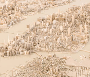
NYC DoITT builds 3D building massing model with 1,000,000 buildings
New York City’s Department of Information Technology and Telecommunications (DoITT) needed a 3D building massing model for the City’s 1,000,000 buildings. AppGeo worked with DoITT to define the approach and data model, manage the effort, and provide QA/QC.
AppGeo successfully generated the 3D building models, which were used alongside planimetric data to support new ways to model and analyze the built environment and City landscape. This resulted in a comprehensive study published by The New York Times that mapped shadows across the City. The City provided access to the 3D data along with viewing tools.
The 3D building massing model created with the FME Platform allows decision makers in New York City to more effectively plan for infrastructure, transportation, and other projects that affect the built environment. It also enables city planners and architects to make informed decisions about building designs, solar potential, and more.


