5 Ways to Do More with Mapnik

Mapnik is a free, open source toolkit that takes vector and raster spatial data and renders it into a beautiful image. As of FME 2014, FME and Mapnik have been brought together to create the MapnikRasterizer.
Adding a Mapnik transformer to FME is like adding a top hat to Abraham Lincoln: it brings a whole new level of style and class. While FME can already take plain vector data and render it as a raster, Mapnik brings a new level of elegance and quality offered by subpixel anti-aliasing. It also offers a cleaner replacement to many FME transformers that do regular image processing. Rasters that once needed dozens of transformers to render now need only a handful. Mapnik is certainly a top hat on FME’s rasterizing capabilities—so what does FME bring to Mapnik? We offer 5 improvements below. Be sure to join our webinar on May 7, 2014 at 8am PDT to see Mapnik examples that will change the way you think about cartography!
1. Read and write more data formats than Mapnik currently supports
When you work with spatial data, being limited to a handful of formats is like having a cartographer sit on you and stuff your arms in a straitjacket. (Constricting, yes, but also painful and awkward.) At the time of writing, Mapnik can read Esri Shapefiles, PostGIS, TIFF raster, OSM XML, Kismet, and OGR/GDAL formats. FME broadens that format reach to include 325+ vector, raster, 3D, tabular, database, web, XML, cloud (and more) formats. This means it’s easier than ever to work with Mapnik from a variety of systems and applications. FME’s data integration capabilities offer precise control over the source and destination data, including over coordinate systems and reprojection.
2. Automate Mapnik workflows
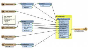
When you design a workflow involving Mapnik, you can use any of FME’s 400+ transformers to validate the data, optimize data before processing it, or restructure it to meet requirements. From there it’s easy to turn all your Mapnik rendering tasks into standard, repeatable actions. You can perform the same data transformations on many datasets, or on a single dataset that constantly changes. This is really good news, because the data workflow you spent so long creating shouldn’t have to disappear forever. This isn’t an ice sculpture contest. (By the way, Mapnik currently runs on Windows, Mac, and Linux, and so does FME.)
3. Wile those tiles, OSM style! (i.e., set up a Mapnik WMTS/WMS with FME Server)
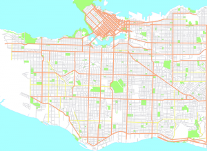
With FME you can take advantage of scalable automation by creating a Mapnik workflow and uploading it to FME Server or FME Cloud. Whether your server needs are big or small, it’s easy as that to make your data available and real-time. You can create a web service that serves map tiles in a standard way; for instance, you could serve OpenStreetMap (OSM) data as a backdrop, stylized in a way that meets your needs.
4. Easy Mapnik styling – goodbye Python, hello GUI
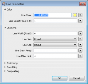
Mapnik offers precise control of symbology and styling, including fill color, dash pattern, fonts, etc. FME makes it intuitive to control it all. Back in 2011, FME users could leverage Mapnik with Python. Today, the MapnikRasterizer makes this much simpler with a friendly GUI. Thank God, because I didn’t want to touch that Python script with a 39½ foot pole. The MapnikRasterizer transformer doesn’t require any CSS or XML skills: it simply accepts parameters in a point-and-click interface like the rest of the FME transformers.
5. Win stuff for sharing your Mapnik art
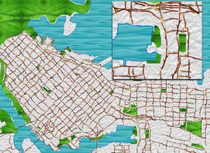
Ok, Picasso. We’re giving out prizes for your Mapnik art! What can you create using FME and Mapnik? Whatever it is, I hope it’s less creepy than this. Together, Mapnik and FME help create beautiful and meaningful cartography worth sharing. If you think you’re the ultimate Mapnik Master, enter our Mapnik contest. (Deadline: June 30, 2014) ![]() I said adding Mapnik to FME is like adding a top hat to Abraham Lincoln – but maybe adding FME to Mapnik is a shift into Abraham Lincoln: Vampire Hunter. FME brings hardcore data transformation and automation capabilities to your Mapnik projects. With FME Desktop, FME Server, and FME Cloud at your fingertips, the potential to create amazing cartography is endless. Thanks to the Mapnik team for making such great cartography possible in FME. What will you do with Mapnik? Be sure to share your creations with us in our contest, and tune in to next week’s webinar to learn more. For technical resources on the MapnikRasterizer, check out the MapnikRasterizer FME transformer documentation, and these Mapnik tutorials on FMEpedia.
I said adding Mapnik to FME is like adding a top hat to Abraham Lincoln – but maybe adding FME to Mapnik is a shift into Abraham Lincoln: Vampire Hunter. FME brings hardcore data transformation and automation capabilities to your Mapnik projects. With FME Desktop, FME Server, and FME Cloud at your fingertips, the potential to create amazing cartography is endless. Thanks to the Mapnik team for making such great cartography possible in FME. What will you do with Mapnik? Be sure to share your creations with us in our contest, and tune in to next week’s webinar to learn more. For technical resources on the MapnikRasterizer, check out the MapnikRasterizer FME transformer documentation, and these Mapnik tutorials on FMEpedia.


